Students attend educational storm spotter meeting provided by The Sky Club
 By: ALYSSA MCCUTCHAN
Staff Writer
The Sky Club at St. Louis Community College – Meramec hosted the third annual National Weather Service meteorology event in the campus theater from 6p.m. to 9:30p.m. Thursday Feb. 19, 2015.
Warning Coordination Meteorologist Jim Kramper from the National Weather Service of St. Louis spoke at the event.
Participants had the opportunity to train as storm spotters.
“It is important to know how to protect yourself,” Kramper said. “My job is not to save your life, it’s you – there is only so much we can do.”
Part of knowing how to protect oneself is to know some basic terminology during times of severe weather.
Watch: Conditions are favorable for the hazard to occur.
Warning: The hazard is likely already occurring
Other important factors of learning how to protect oneself in severe weather are to know where to receive such warnings and to pay attention to weather forecasts.
Television and radio are the top methods to receive such information, Kramper said. If caught amidst severe weather, quick decisions can save a life. Judge the situation and make the best choice.
The basement is the best place to go in cases of severe weather besides flooding. DO NOT drive in cases of severe weather.
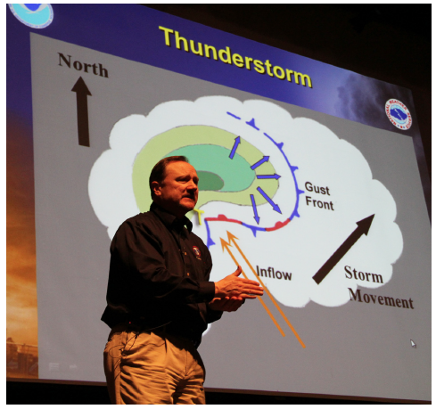
According to Kramper, there is one major reason why Missouri weather is “crazy” and that is geography.
Cold air comes down from the arctic and warm moist air comes up from the Gulf of Mexico. These two opposing climates meet in the central parts of United States creating a wide range of weather patterns. Thunderstorms are the most common form of extreme weather in the Midwest, he said.
How does an area get thunderstorms?
• Warm Moist Air
• Unstable Atmosphere: air wants to rise
• Triggers: cold fronts, warm fronts, low pressure, daytime heating
• Wind Shear
• Updraft
“Warm moist air is the fuel supply for thunderstorms in the atmosphere,” Kramper said. “The atmosphere is unstable, with air consistently wanting to rise.”
The higher the air rises, it reaches colder temperatures, which causes the warm moist air to cool.
When the water temperature drops it becomes condensation, creating clouds. It is when condensation gets pushed out of the updraft of warm airflow and becomes weak that it produces rain. The rain is known as the downdraft. A wind shear is when 2 columns of air that pass in different directions at different speeds. The combination of a strong updraft (warm-moist air) and a strong downdraft (rain) creates perfect conditions for a thunderstorm (or other extreme weather), he said.
“Nearly 60 percent of all severe storms trek toward the northeast driven by south warm moist wind,” said Kramper.
Another form of extreme weather in the Midwest apart from thunderstorms are tornadoes.
“A funnel cloud and tornado is not the same thing.” Kamper said.
It is not classified as a tornado until dust and debris appear from the ground. Not all tornadoes appear in the traditional form of what one may assume, he said.
“Only 16 percent [of tornadoes] don’t get much bigger than skinny little things,” Kramper said.
The National Weather Service is always looking for spotters to report information on weather patterns in local communities as well as damage caused by storms, said Kramper.
The NWS needs help from locals to be the eyes and ears in every county in Missouri. There is a multitude of things that need to be reported.
Things to report include:
• Tornadoes, funnel clouds, and wall clouds
• Wind: 58 mph or more is considered severe weather. All damage is to be reported: trees, power lines, roof damage, etc.
• Hail: communicate the size of hail spotted. One-inch hail is the criteria to be considered a severe thunderstorm warning. Report all hail sized no matter the size.
• Flooding: flooding is the number one cause of death in the United States, higher than tornadoes. Six inches of swiftly flowing water can knock down a person while each foot of water exerts 500 lbs of force.
• Winter storms: snow, ice, sleet, freezing rain, etc. It is helpful to measure the amount (inches/feet) of snow and thickness of ice on surfaces.
Reporting weather patterns helps the NWS know how to better serve the community and improve on future weather pattern predictions, Kramper said. Local volunteers are a valuable source of information in confirming predicted and unpredicted patterns in specific areas.